REVIEW · KAANAPALI
Maui: Waterfalls of West Maui and Molokai Helicopter Tour
Book on GetYourGuide →Operated by Blue Hawaiian Helicopters · Bookable on GetYourGuide
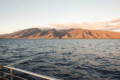
Flying above Molokai wakes you up fast. This West Maui and Molokai helicopter tour is built for big views: 88 miles of coastline, towering waterfalls, and rainforest valleys you just can’t reach by car. I love the way the route mixes natural drama (sea cliffs, waterfalls, knife-edged peaks) with real place-names, so the sky feels like a guided tour.
Two things really win me over. First, the Bose Aviation-grade noise-cancelling headsets make the narration clear instead of mumbled. Second, your pilot is also a State of Hawaii Certified Tour Guide, so you’re not just watching scenery—you’re getting the story as you fly past it. One consideration: at $419 per person for a 50-minute flight, it’s a splurge, so you’ll want to be sure you’re the type who values time-saving, once-from-the-air views.
In This Review
- Key highlights from the air
- West Maui and Molokai from the sky: why this route works
- The helicopter experience: Eco-Star, Bose audio, and pilot-guide storytelling
- Starting at Kahului: the launch point and what to watch for
- West Maui Mountains: valleys, ridges, and mist-covered peaks
- Kahakuloa Bay and the Pailolo Channel: remote beauty signals
- Puu Kukui and Mauna Kahālāwai: the view from Maui’s high ground
- Molokai north shore waterfalls and world-high sea cliffs
- Ka’anapali, Kapalua, and Pelekunu Bay: rounding the circuit
- Timing, group size, and the reality of check-in
- Price and value: is $419 per person worth it?
- What to bring (and what to leave behind)
- Who this tour suits best
- Should you book this West Maui and Molokai helicopter tour?
- FAQ
- How long is the helicopter tour?
- Where does the tour depart and end?
- What is included in the price?
- Is transportation to and from the heliport included?
- Can I bring a hat or selfie stick?
- What is the check-in time?
Key highlights from the air
- 88 miles of untouched coastline with waterfalls plunging toward the sea on Molokai’s north shore
- Eco-Star helicopter setup for touring, plus Bose Aviation-grade electronic noise-cancelling headsets
- Live pilot-guide narration with 2-way communication through onboard microphones
- Mist-covered West Maui Mountains views, including the high point area around Puu Kukui
- Molokai’s world-highest sea cliffs and the Kalaupapa community from above
- A small group capped at 6 for a more personal feel
West Maui and Molokai from the sky: why this route works
This tour is special because it doesn’t just do a generic loop. It strings together two islands with a clear visual theme: raw coastline, dramatic drop-offs, and wet, green mountain shapes that look almost folded from the clouds.
From the air, waterfalls and cliffs stop being background scenery. Water has weight here. You can actually trace how it falls off sea cliffs and how it carves through gullies on land. And because the flight is short—50 minutes—you get a lot of “wow” without losing half a day to transfers or long drives.
The route also makes sense geographically. Maui’s Windward-side valleys and ridges sit close enough to read clearly from above, and then Molokai’s north shore gives you that unmistakable wall of sea cliffs. If you’re visiting Maui for limited time, this is one of the most efficient ways to add Molokai to your trip without making it a multi-day commitment.
You can also read our reviews of more tours and experiences in Kaanapali.


The helicopter experience: Eco-Star, Bose audio, and pilot-guide storytelling
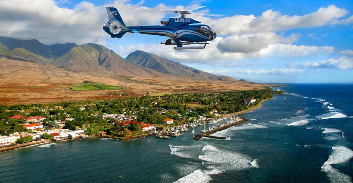
The helicopter matters. This is done in a state-of-the-art Eco-Star, designed for touring, and that shows in how stable and view-friendly it feels. The big practical win is audio. You’ll use Bose Aviation-grade electronic noise-cancelling headsets, so you can hear both the narration and the recorded commentary via the headphones.
On top of that, you get microphones with 2-way communication with the pilot. Translation: you’re not stuck listening to a one-way script. Your guide can respond, steer the focus, and point out what matters as you pass it.
Also, your pilot is a State of Hawaii Certified Tour Guide. That detail is more than paperwork. It means the commentary sticks to place-based context—history and culture topics, plus ancient island traditions—so the flight isn’t just pretty pictures. It’s explanation that helps you recognize what you’re seeing.
One small note for your comfort: you’ll want to plan for check-in timing carefully. Late arrivals aren’t accepted and are non-refundable, and you check in 45 minutes before your flight.
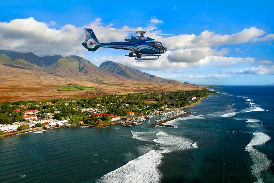
Starting at Kahului: the launch point and what to watch for
Most helicopter tours start somewhere convenient. This one starts at Kahului Heliport, and the way you leave Kahului matters because you’re transitioning quickly from “city + access roads” to “mountain and ocean country.”
As you depart, you pass over:
- Kahului: described as the economic heart of Maui, but from the air you also get strong sight lines toward Haleakala and the West Maui Mountains. This is your first chance to orient. Look for where the land rises and how the coast curves.
- Wailuku: an ancient population center and gateway to the ’Iao Valley and West Maui Mountains. From above, it helps to imagine the valley as a corridor—an entry point that controls how weather and greenery move through the area.
If you like having mental anchors, these early stops are good. They help you understand the flight isn’t random; you’re being guided across Maui’s shape.
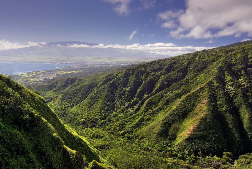
West Maui Mountains: valleys, ridges, and mist-covered peaks

This is the heart of the “green and wet” part of the tour. You’ll fly above lush, meandering valleys deep in the West Maui Mountains, with knife-edged, mist-covered peaks described as a signature of the area.
What to watch for:
- Ridge lines: from above, ridges look like long ribs. They often create the sense of mist hugging edges rather than spreading evenly.
- Valley curves: the route tends to follow how water would travel through the terrain. You can often see branching channels and the way fog sits lower in the folds.
You’ll also pass Waihee, known for its lush ridge lines and dramatic scenery. Even if you don’t know the names on the ground, the aerial look makes the category clear: wet slopes, sharp divisions between ridges, and a layered feel as the terrain drops away.
Kahakuloa Bay and the Pailolo Channel: remote beauty signals
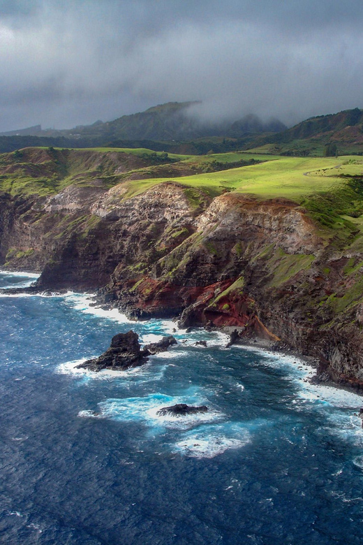
After the mountain mass, the tour shifts toward coastline variety. Kahakuloa Bay is described as a remote former fishing village, and that label comes with an aerial clue: you can see how isolated the coastline looks compared with the more developed beaches.
Then you’ll fly over the Pailolo Channel. Channels are great from the air because they’re natural dividers. Even if you’re not studying charts, you can spot the waterway as a clean break between island shapes and ocean texture.
These sections are the “keep your phone put away” part of the flight—because the best photos usually come from steady looking, not frantic framing.


Puu Kukui and Mauna Kahālāwai: the view from Maui’s high ground
One stop name you’ll hear is Puu Kukui, noted as the highest peak of Mauna Kahālāwai (West Maui Mountains). From the air, high points like this read as a blunt-to-sharp peak profile, depending on cloud cover.
This is a moment for patience. If you rush your looking, you miss what makes the mountains feel different here: the edges and slopes don’t blur into one green surface. They show depth, and mist can make distances hard to judge in a good way.
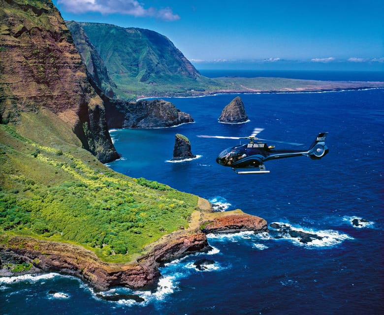
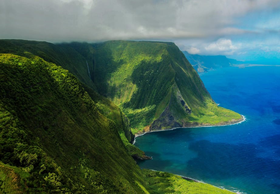
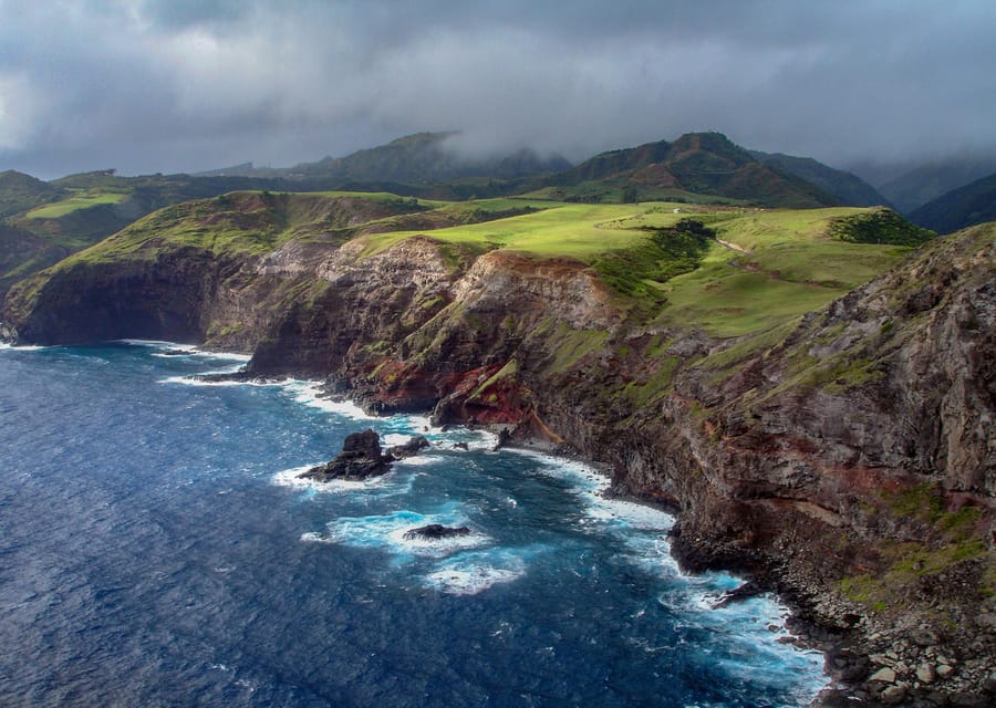
Molokai north shore waterfalls and world-high sea cliffs
Then the flight turns dramatic. Molokai comes with the highlight you came for: waterfalls that plunge from sea cliffs into the turquoise sea on the north shore.
This is the part where you stop thinking in terms of “land versus ocean.” The cliffs make the transition instant. You see the shape of water dropping down, then spreading as it hits the ocean surface.
A key marker is Molokai’s world-highest sea cliffs, plus the Kalaupapa community you’ll admire from above. Even without more ground context, the aerial view gives you respect for how that coastline works—steep, exposed, and shaped by weather.
If you’re the kind of person who loves seeing how nature forces human settlement patterns, this section gives you that feeling fast.
Ka’anapali, Kapalua, and Pelekunu Bay: rounding the circuit
After Molokai, the tour circles back toward Maui’s west side, including:
- Ka’anapali: beaches and crystal-clear waters.
- Kapalua: beaches, golf courses, and varied views.
This is your “compare textures” segment. Molokai gives you cliff drama and waterfall drops. Maui’s west side gives you lighter water color and more beach geometry. Together, they make it easier to understand how the coastline changes across the islands.
Then you’ll fly over Pelekunu Bay, flanked by the world’s highest sea cliffs and containing one of Hawaii’s last free-flowing streams (as described for this area). That combination—cliff edge plus a still-active flow—creates a clear aerial storyline: you can look for the stream line and follow how it disappears toward the ocean.
For photography, this section is bright. Wear dark-colored clothing if you can, since the tour recommends dark colors so you don’t reflect in photos.
Timing, group size, and the reality of check-in
The flight is 50 minutes, but plan your day around the 45-minute early check-in. You’ll want enough buffer to park, find your way in, and get seated without rushing.
The group is small with a maximum of 6 participants. That matters more than people think. Helicopter seating can feel tight, and a small group keeps the experience calmer. It also improves your odds of hearing the guide well as you move around in your seat.
This tour is also listed as wheelchair accessible, so if mobility is a factor, you’re not automatically locked out of the experience.
Price and value: is $419 per person worth it?
At $419 per person for a 50-minute flight, this isn’t a budget activity. The value comes from three things you’re paying for:
- Access: You’re seeing waterfalls off sea cliffs, knife-edged peaks, and Molokai’s north shore features from the air. Ground views exist, but this specific collection of angles is a helicopter advantage.
- Narration quality: You get a State of Hawaii Certified Tour Guide pilot plus Bose Aviation-grade headsets and 2-way communication, not just a prerecorded audio track.
- Time efficiency: If you only have limited time on Maui, the tour compresses a lot of highlights into one short window.
A potential trade-off is that you’re paying for time in the air. If you’d rather spend your time on the ground exploring hikes, beaches, or viewpoints, you might prefer other Maui activities. But if your travel style is “see more of the island shape, fast,” this price starts to look more like a shortcut than a splurge.
What to bring (and what to leave behind)
Keep it simple. Bring passport or ID. Dress for photos—dark-colored clothing helps reduce reflections. And follow the restrictions so staff can keep the flight smooth.
Not allowed:
- Hats
- Luggage or large bags
- Selfie sticks
That last one matters because it’s usually a safety and handling issue in a small aircraft cabin. If you want photos, use your phone normally and keep your hands and gear tucked away.
Also, a practical comfort detail: for guests over 240 lb (108 kg), an adjacent empty seat is required for balance. The second seat is half off the regular tour price, and you arrange the additional seat after booking.
Who this tour suits best
This is a strong fit if you:
- Want the fastest way to include Molokai while staying on Maui.
- Enjoy guided context, not just scenery drifting by.
- Appreciate clean audio and a pilot who can explain what you’re seeing as you fly past it.
It may be less ideal if:
- You’re expecting a long, on-the-ground sightseeing day.
- You’re very price-sensitive and prefer to spend money on food or hotels instead.
- You’re counting on bringing bulky personal items, hats, or selfie sticks.
Should you book this West Maui and Molokai helicopter tour?
If you want one “island from above” experience that hits West Maui Mountains, Molokai’s north shore cliffs, and waterfall drama in a single shot, I’d say yes, book it—as long as the cost fits your trip priorities. The combination of small group size, Bose Aviation-grade headsets, and a certified pilot-guide makes the experience feel controlled and informative, not chaotic.
If you’re unsure, think about your travel goal. Are you chasing views you can only get from the air? If yes, this is one of the most direct ways to do it in Maui. If you’d rather explore slower on the ground, you might get more satisfaction elsewhere with the same money.
FAQ
How long is the helicopter tour?
The tour duration is 50 minutes.
Where does the tour depart and end?
The tour departs from and concludes back at Kahului Heliport.
What is included in the price?
Included are the helicopter flight, a State of Hawaii Certified Tour Guide/pilot, tour narration, Bose Aviation-grade electronic noise-cancelling headsets, microphones for 2-way communication with the pilot, and an after-tour video preview at the heliport.
Is transportation to and from the heliport included?
No. Transportation to and from the heliport and parking fees at the heliport are not included.
Can I bring a hat or selfie stick?
No. Hats and selfie sticks are not allowed, and luggage or large bags are also not allowed.
What is the check-in time?
Check-in is 45 minutes prior to tour time. Late arrivals may not be accepted and are non-refundable.